Glenshellish Farm
Strachur, Cairndow, Argyll & Bute, PA27 8DJOffers Over £875,000
164.49 acres
5
2
2
- Closing Date Set: 12.00 noon on Wednesday, 2 October 2024
- Attractive 5-bedroom B-listed farmhouse with large area of garden ground
- Large range of traditional B-listed buildings set in a horseshoe formation
- Adaptable and useful range of modern outbuildings and yard area
- Productive areas of Grade 4 and Grade 5 grazing and silage ground
- Land and buildings with development potential (subject to obtaining the necessary planning consents)
- Located in a private and accessible location on the Cowal Peninsula
- Panoramic views over the surrounding countryside
- About 66.57 Ha (164.49 Acres)
- For sale as a whole or in 4 lots
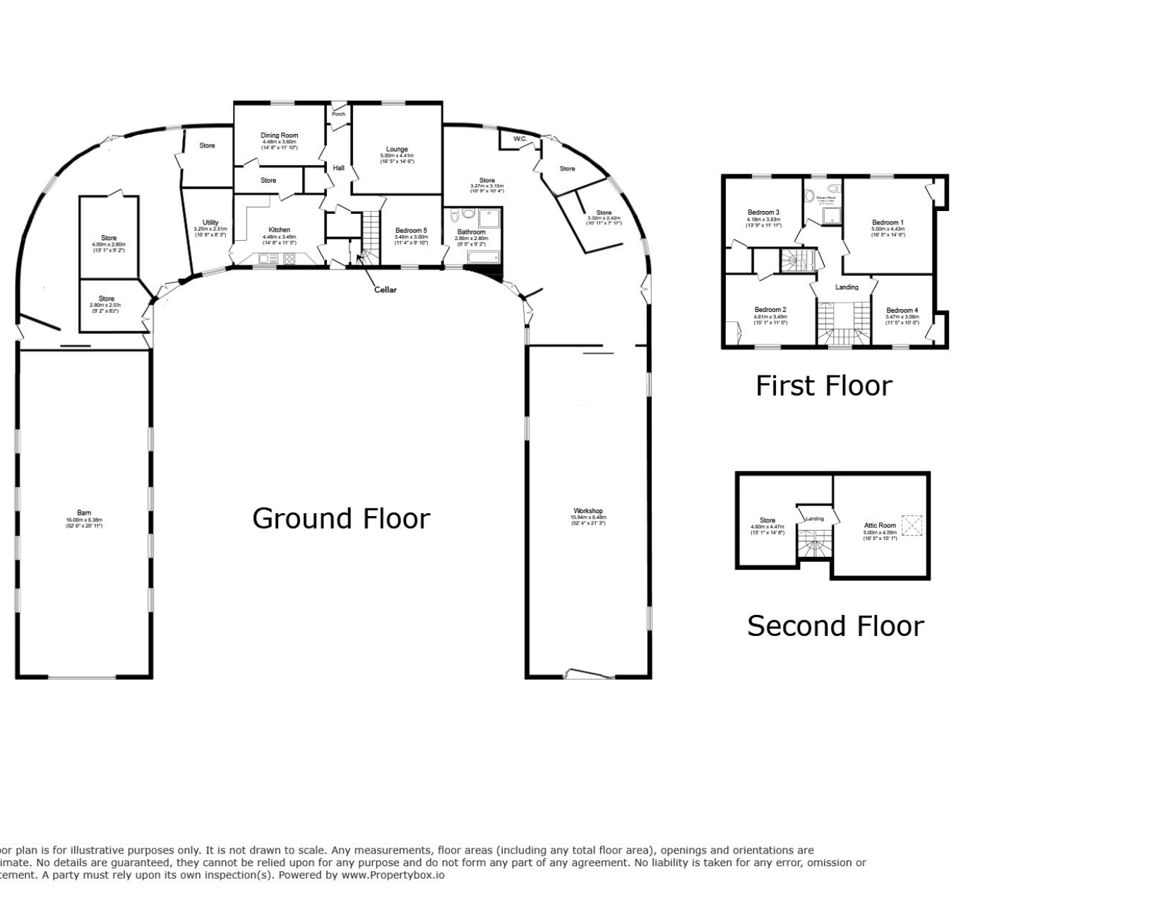
SITUATIONGlenshellish Farm is an attractive residential and farming unit situated in a scenic area of the Cowal Peninsula on the West Coast of Scotland, a short distance from the village of Strachur. The village of Strachur is located on the eastern banks of Loch Fyne and offers a range of local amenities such as a post office, churches, a hotel, pubs, a village hall and a local shinty club.The picturesque town of Dunoon 16 miles to the south is the main town on the Cowal peninsula, and home to a busy ferry terminal which operates regular ferry services to Gourock, which take approximately 25 minutes. The town offers a wide range of shops, restaurants, schools, leisure centre, events hall, supermarkets, sports stadium, hospital, garden centre, golf course and holiday village.The area is connected by an excellent road network and provides wider travel networks to Glasgow and beyond. The county of Argyll is known for its stunning scenery, extensive wildlife and choice of outdoor pursuits including walking, climbing, cycling and its wide range of water sports.Glenshellish is located on the western periphery of the Loch Lomond & The Trossachs National Park, an area renowned for its scenic beauty and populated with lochs and rivers to explore as well as numerous castles, distilleries, and forests. The area is also a popular field sports destination with a number of landed estates offering fishing along with driven and walked up game shooting.DESCRIPTIONGlenshellish Farm comprises of an attractive traditional B-listed 5-bedroom farmhouse, which adjoins an impressive range of traditional farm buildings set in a horseshoe formation, which may offer further development potential subject to obtaining the necessary planning consents. There are also several useful modern farm buildings and an area of productive pasture and grazing land extending to approximately 66.57 Ha (164.49 Acres) in total. The farmhouse and steading are situated towards the west of the holding, in an elevated position, with the property being accessed via a shared private road which is owned by Forestry and Land Scotland and leads from the A815.HISTORYGlenshellish Farmhouse and buildings were originally built in 1826 by David Napier the famous Scottish marine engineer and was used as his summer resort. Napier built the first iron steam passenger ship in the world on Loch Eck where he ran daily steamers. It is likely that the stables and outbuildings at Glenshellish Farm were used to house the horses that were used to convey the passengers from Loch Eck to Strachur Pier, hence the farmhouse and outbuildings being formatted within a horseshoe shape. In more recent times the property has been in the Seller’s family ownership for over 60 years and was originally run as dairy up until 1999, and now the majority of the farm land has been let to local farmers on a seasonal basis for fodder and grazing purposes.LOT 1: GLENSHELLISH FARMHOUSE, STEADING AND LAND EXTENDING TO 14.59 HA (36.05 ACRES)FarmhouseGlenshellish Farmhouse forms an attractive traditional stone-built B-listed property under a pitched slated roof, which enjoys panoramic views over the surrounding countryside towards the River Cur and hills to the north of the property. The farmhouse provides spacious family accommodation set out over three levels comprising a connecting kitchen and utility room, large dining room, lounge and a double bedroom with an ensuite modern bathroom which was installed in 2021 on the ground floor, with 4 double bedrooms and shower room on the first floor, and two further attic rooms on the second floor. The accommodation and room dimensions are set out in more detail within the floor plans contained in the particulars.Garden GroundThe property benefits from an attractive and large area of garden ground which surrounds the property to the front of the house and is mostly laid to areas of lawn enclosed with number of flower beds and shrubs providing an abundance of colour. The garden is sheltered by several mature broadleaved trees, and there is also a greenhouse and a small pond towards the east of the garden. The farmhouse can be accessed via a separate drive which leads to the front of the farmhouse where there is a gravel area providing ample parking. There is a cobbled courtyard which included a partially paved patio area to the rear of the property.Garage (5.97m x 5.37m)Located to the east of the farmhouse there is a double garage, of rough-cast brick walls under a pitched corrugated sheet roof with a concrete floor.Farm BuildingsGlenshellish Farm is well equipped with a range of useful traditional and modern outbuildings which lie immediately to the south and west of the farmhouse. The buildings comprise:Traditional Range BuildingsAdjoining the farmhouse to the east and west and extending south, there is a range of traditional B-Listed buildings which are set in a unique horseshoe courtyard formation and are of traditional stone construction under pitched slate roofs with a concrete floor. The buildings enclose an original courtyard which has a cobbled floor, and the buildings are split into various stores, former milking parlour, byre and a coal bunker. The layout and structure of the buildings may present future opportunities for conversion either as part of an extension to the existing farmhouse, or development to other forms of alternative use, subject to obtaining necessary planning and listed buildings consents. The layout and dimensions of the traditional buildings are set out in more detail within the floor plans contained in the particulars.Modern Store Shed (21.11m x 9.37m)Of steel portal frame construction under a tin roof, with stone and block walls and a concrete floor.Former Silage Pit/Slatted Shed (27.5m x 14.9m)Of concrete frame construction under a corrugated roof with shuttered concrete walls and a concrete floor. There is a raised slatted floor along one side of the building which was historically used as calf pens.Lean-to (27.5m x 9.12m)Of concrete frame construction under a corrugated roof with block walls with a slatted floor and a central concrete feed passage.The LandThe land within lot 1 extends to approximately 14.59 Ha (36.05 Acres) in total including roads, yards and buildings and surrounds the farmhouse and steading to the south, east, and west. The land comprises of a mix of permanent pasture and grazing land which is currently utilised for grazing livestock, with a small area of amenity woodland to the east of the farmhouse and steading. The farmland has been predominately classified as Grade 4.2 and 5.3 by the James Hutton Institute. All fields benefit from an excellent level of vehicle access directly from adjacent Forestry and Land Scotland access roads. The land rises from approximately 30m above sea level at its lowest point at the north east boundary of Lot 1, to approximately 94m above sea level at its highest point near the southern boundary with the adjacent woodland plantation.LOT 2: LAND EXTENDING TO APPROXIMATELY 41.79 HA (103.26 ACRES)The land in Lot 2 extends to approximately 41.79 Ha (103.26 Acres) and comprises a contiguous block of temporary and permanent grassland. The land is situated to the north of the farmhouse and steading and stretches to the south east and is bound to the north by the River Cur, and to the west by the Glenshellish Burn. The land has been predominately classified as Grade 4.2 and 5.1 by the James Hutton Institute and is generally level in aspect rising overall from approximately 21.5m above sea level at its lowest point towards the south east to approximately 31.5m above sea level at its highest point towards the west of the parcel of land. An area of the land towards the south west forming field 8 on the sale plan falls within the Loch Eck Site of Special Scientific Interest (SSSI). The land to the west of Lot 2 has historically been cut for hay and silage with the land to the east predominately used for grazing. The land benefits from access into each enclosure via the Forestry and Land Scotland access road which bounds the subjects to the south.LOT 3: LAND EXTENDING TO APPROXIMATELY 4.23 HA (10.45 ACRES)The land in Lot 3 extends to approximately 4.23 Ha (10.45 Acres) and comprises a contiguous block of pasture ground which is currently utilised for grazing and lies immediately to the east of the residential properties at Glenbranter. The land is bound to the east and south by the River Cur and Glenshellish Burn respectively and is accessed via the internal forestry road which falls under Forestry and Land Scotland ownership. The land has been predominately classified as Grade 4.2 by the James Hutton Institute and sits approximately 28m above sea level at its lowest point towards the south and rises to approximately 35m above sea level at its highest point towards the north of the enclosure. There are several areas of mixed amenity woodland which split the land into 3 different enclosures and there are a number of mature trees along the river bank providing an attractive backdrop and shelter to the enclosures.LOT 4: LAND EXTENDING TO APPROXIMATELY 5.96 HA (14.73 ACRES)The land in Lot 4 extends to approximately 5.96 Ha (14.73 Acres) and comprises 2 separate enclosures which are situated to the south of and adjacent to the A815. The land comprises a mix of pasture and grazing ground with several small areas of amenity woodland. The land has been predominately classified as Grade 4.2 by the James Hutton Institute and is partially bound to south by the River Cur. Overall the land rises from approximately 24m above sea level at its lowest point on the south east parcel to 28.5m above sea level at the northern parcel. The enclosures are accessed directly via field gates which lead from the A815.