Canderside Farm
Stonehouse, Larkhall, South Lanarkshire, ML9 3PJOffers Over £1,690,000
306.13 acres
3
2
- Traditional farmhouse with large area of garden ground
- Pair of semi-detached cottages in a ruinous state
- Useful and adaptable range of traditional and modern farm buildings
- Traditional buildings with development potential (subject to necessary consents)
- Productive block of Grade 3.2 arable and silage ground with a smaller area of Grade 6.1 land
- Excellent access on to adjacent public roads and M74 motorway
- Areas of amenity woodland
- About 123.89 Ha (306.13 Acres)
- For Sale as a Whole or in 5 Lots
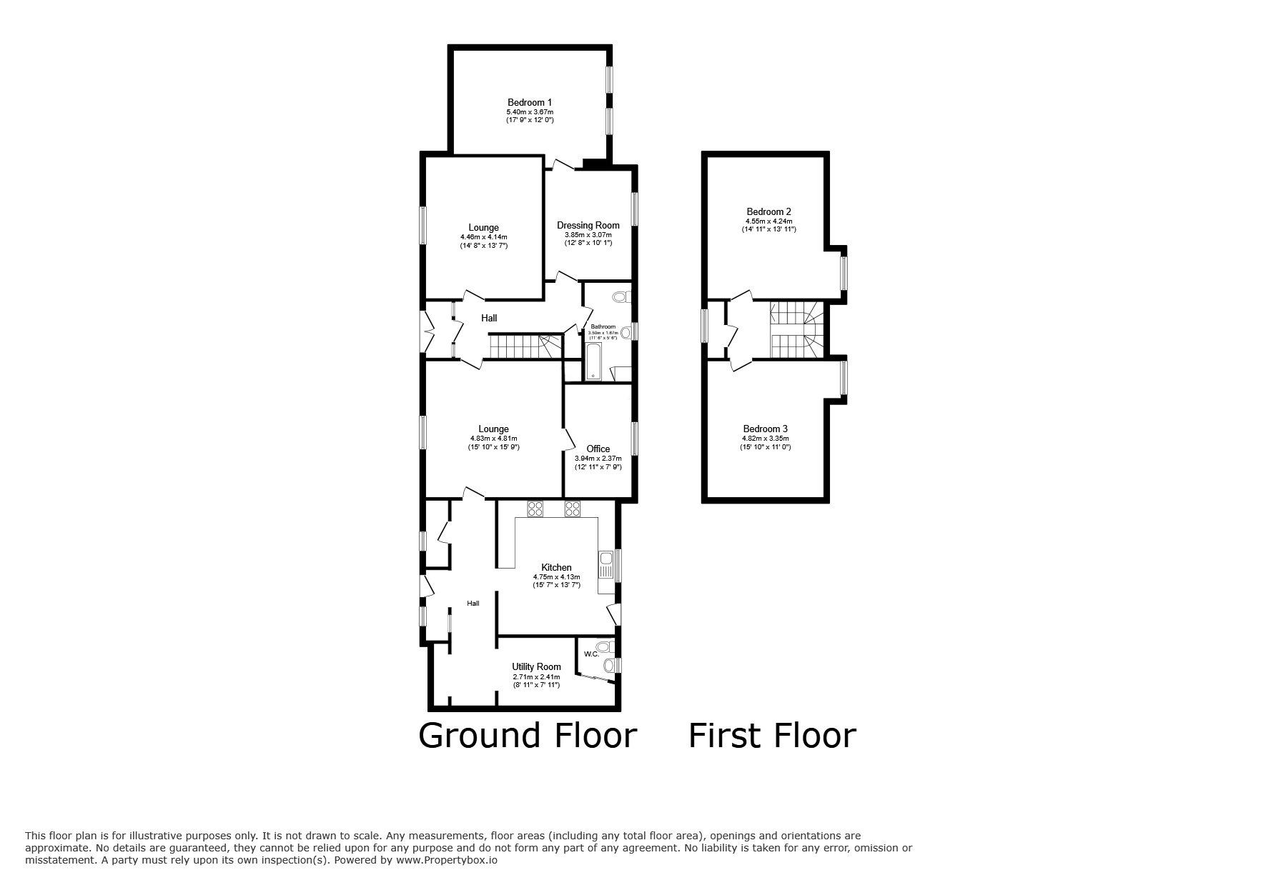
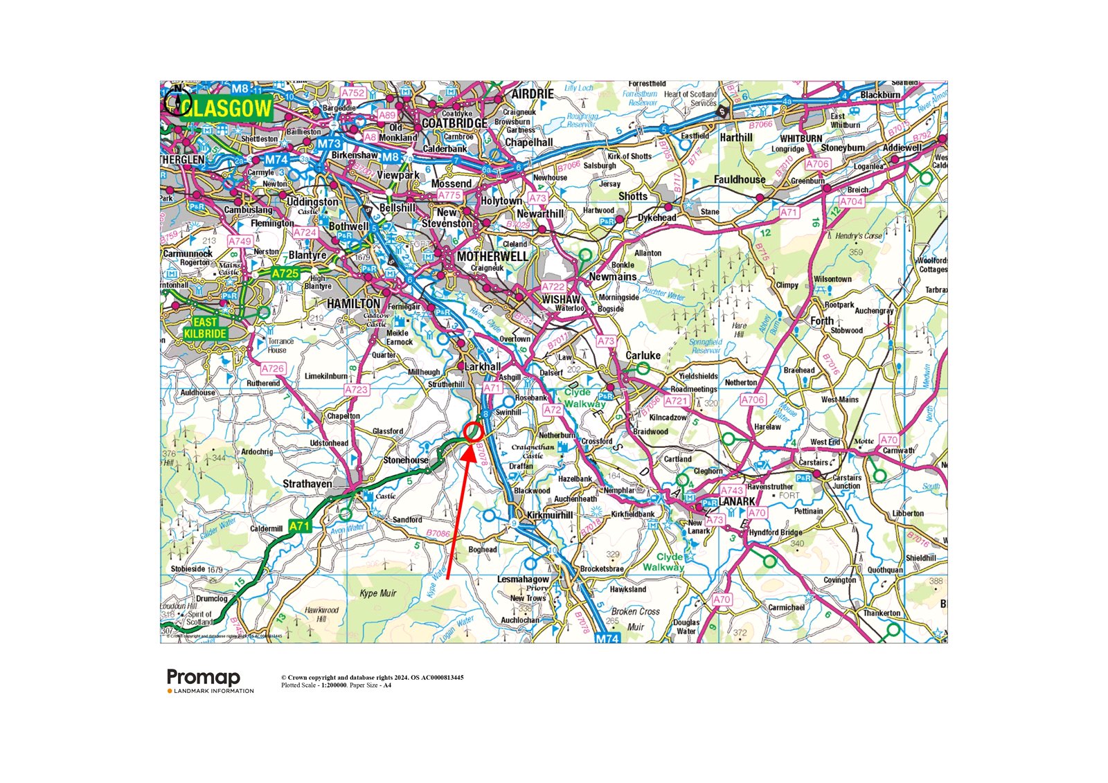
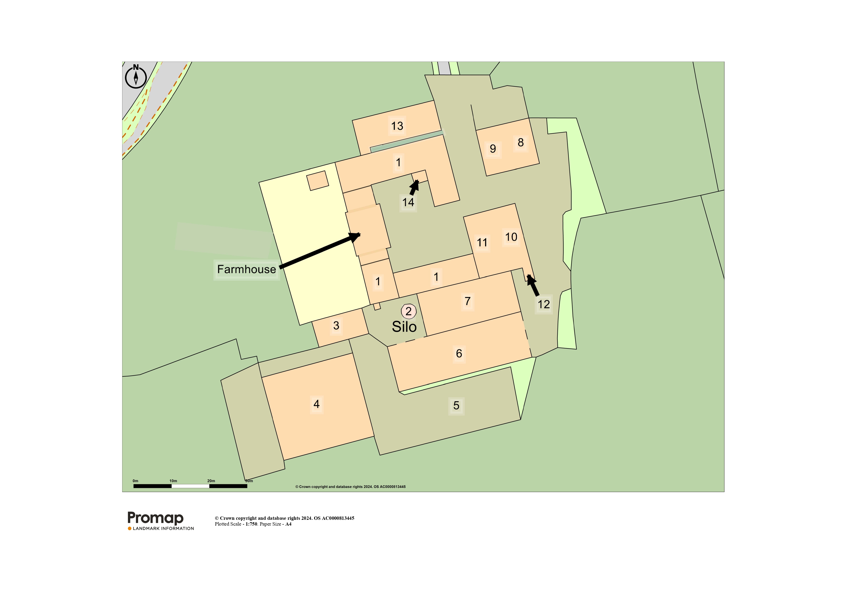
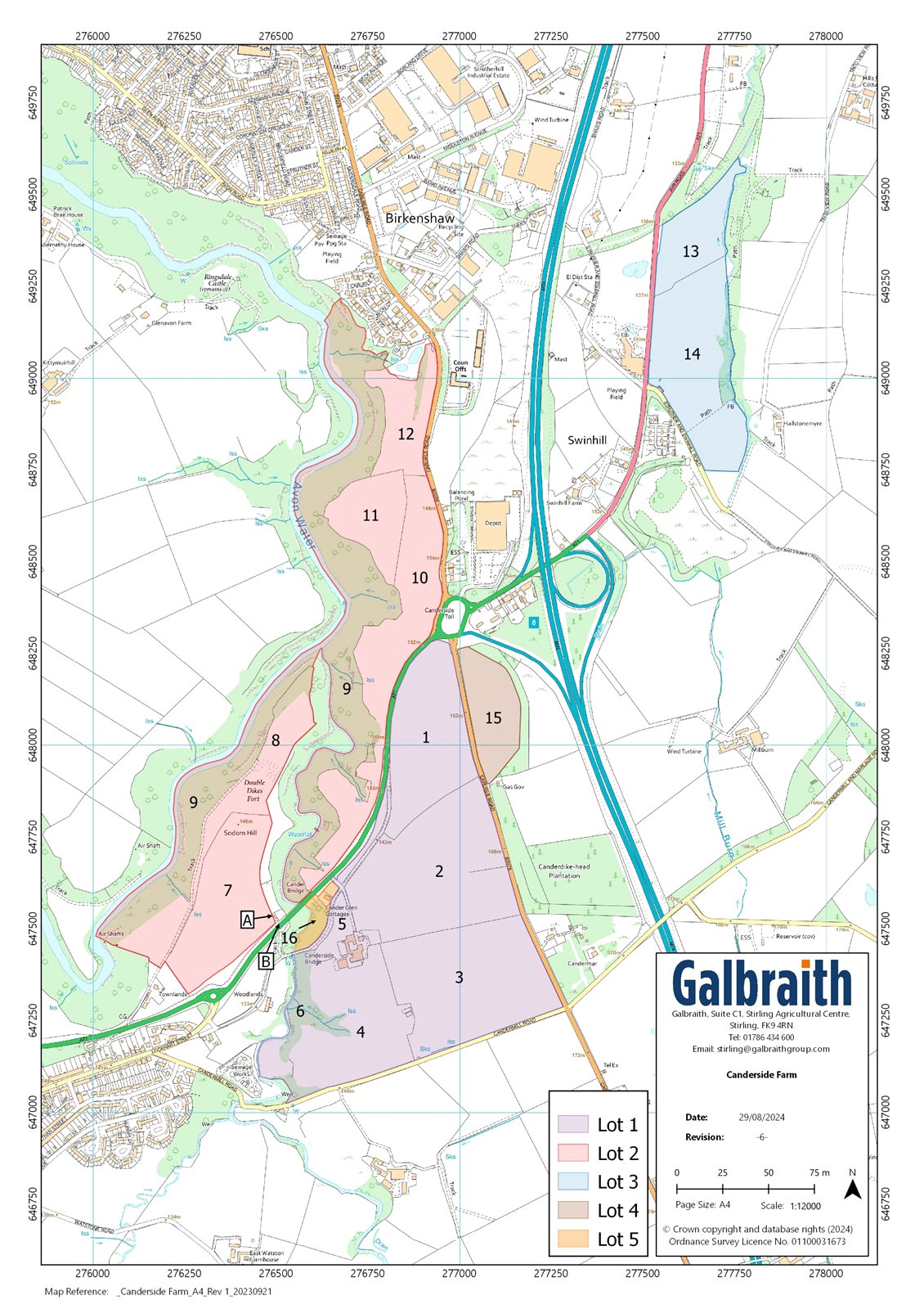
SITUATIONCanderside Farm comprises a productive mixed farming unit situated between the village of Stonehouse and the town of Larkhall within rural South Lanarkshire. The farm bounds the village of Stonehouse to the west, which offers a range of day to day amenities including a butcher, pharmacy, Co-op and local service station as well as a doctors, dentist, opticians and two Primary Schools. The nearby town of Larkhall some 2.5 miles to the north, provides a wider range of local services and amenities.Canderside Farm falls within the Larkhall Academy catchment for secondary schooling, with private schooling available at nearby Hamilton College or there are a wider range of highly regarded independent schools within the City of Glasgow.The farm benefits from excellent road links via the A71 which passes at the end of the farm drive and provides swift access to Junction 8 of the M74 motorway to the east, offering easy access to the whole of Central Scotland, making Canderside within about an hour’s drive from both Edinburgh and Glasgow. There is a railway station at Larkhall, which is on the Argyle Line, offering regular services to Glasgow Central every 30 minutes.The City of Glasgow, Scotland’s largest city, is 20 miles north west of the farm, with world-renowned shopping outlets, businesses and entertainment facilities. Glasgow Airport is about 26 miles away and offers regular flights throughout the UK, Europe and beyond. The larger towns of Hamilton, East Kilbride and Motherwell are within easy reach by car, and all provide an excellent and wide range of shops, professional services and transport links.The farm benefits from a private and attractive outlook across the surrounding countryside to the east and west. The surrounding area is home to an array of wildlife and provides plenty opportunities for the outdoor enthusiast, with country walks at the nearby Chatelherault, Strathclyde and Calderglen Country Parks and several more local core paths located a short distance from the property. There are many highly regarded golf courses in the area including Lanark, Hamilton and Strathaven, with the championship courses at the Old Course at St Andrews, Gleneagles and Muirfield all within a couple of hour’s drive from the property.Agriculturally, the surrounding area of South Lanarkshire provides an attractive location with a combination of productive pasture and arable ground. The area is well known for being well located close to agricultural amenities, including agricultural machinery sales and service in Strathaven and Lanark. Feed merchants are available in Stonehouse and Strathaven. The farm is also within easy reach of a number of livestock markets, including Lanark Mart (12 miles), Ayr (35 miles) and the two livestock marts in Stirling (about 40 miles).FARMING SYSTEMThe Sellers have owned Canderside Farm since 1921, having been tenants for many years prior to its purchase. Historically, the farming system at Canderside focused on a mixed dairy, beef and arable system, with cereals and grass grown as part of the rotation. All of the grain, straw and silage were used for home consumption. The farm ran a closed herd of 80 dairy cows, with replacement heifers kept as followers and bullocks taken through to finishing. The dairy cows were reduced in recent years and replaced by suckler cows and followers which were taken through to finishing. The suckler cows were then replaced by 100 store cattle which were dispersed in 2023.Most of the land has now been let out on seasonal grazing and cropping agreements. The use of rotation and healthy application of farmyard manure from both the dairy and beef enterprises on the holding over the years, has ensured all of the ploughable arable and pasture has been worked to a good depth, and a continuous programme of ditching and drainage works has allowed the farmland to be utilised to its maximum potential. The fields are well laid out and generously sized, easily accommodating modern machinery, and are readily accessible directly from adjacent public roads or via an excellent network of internal tracks and farm roads.DESCRIPTIONCanderside Farm presents a productive mixed farming unit extending to approximately 123.89 Ha (306.13 Acres) and is centred on a traditional farmhouse which forms part of the courtyard steading, centrally located within the holding, just south of the A71 public road. The holding benefits from an excellent range of modern and traditional farm buildings and a pair of semi-detached cottages located adjacent to the farm drive, which are largely in a dilapidated state but remain relatively intact to wall and roof head level, presenting further development opportunities, subject to obtaining the necessary planning and building consents.The farmland is divided into four separate blocks by the adjacent public roads. The two principal blocks are located on either side of the A71, with the largest area of arable and silage ground surrounding the farmhouse and steading at Canderside, with a further area of grazing and arable ground located to the north of the A71 which includes a large area of mixed amenity woodland which is bound to the west by the Avon Water. The third area of arable and grazing land is located to the east of the M74, opposite the Radstone Hotel, and bound to the west by A71, with the final smaller parcel of arable land located to the north east of the farm steading and accessed directly off the B7078 public road, just to south east of the Canderside Toll Roundabout.The land has principally been classified by the James Hutton Institute as Grade 3.2, with a small area of Grade 6.1 surrounding the Avon and Cander Water. The land varies in aspect, rising overall from 98m above sea level at its lowest point near the town of Larkhall to 174m above sea level at its highest point on the south eastern boundary of the property adjacent to the B7078.METHOD OF SALECanderside Farm is offered for sale as a whole or in 5 Lots. Please note Lots 2-5 will not be sold prior to the sale of Lot 1.LOT 1: FARMHOUSE, FARM BUILDINGS AND LAND EXTENDING TO APPROXIMATELY 48.08 HA (118.81 ACRES)Canderside FarmhouseThe farmhouse is situated within a traditional courtyard setting and centrally located within the principal block of arable and pasture land. The farmhouse sits in a private position within theholding and benefits from excellent access via the private farm drive which leads to the A71. The house enjoys a westerly aspect with views over the surrounding countryside. The property is constructed from traditional stone under a pitched slate roof and provides spacious accommodation over two levels. Internally, the farmhouse is in need of modernisation but presents a fantasticopportunity to refurbish the accommodation and extend by way of the adjacent buildings to form a substantial family home. The accommodation and room dimensions are detailed in the floor plan contained within the particulars.Garden GroundThe farmhouse is accompanied by a large and private area of garden ground which lies to the rear of the property and is mostly laid to lawn with a small paved patio area, a large vegetable patch, with several apple and plum trees and a greenhouse. The garden is enclosed by several mature trees providing shelter and privacy.Farm BuildingsThe range of modern and traditional farm buildings are situated in a group and lie immediately adjacent to the farmhouse with access via the adjoining public road. The buildings comprise the following:1. Traditional U-shaped SteadingLocated adjacent to the farmhouse, in a courtyard formation, the buildings comprise:Workshop (9.35m x 5.25m) of traditional construction under a slate roof with a concrete floor.Mill Shed (6.2m x 2.09m) of traditional construction under a box profile roof with a concrete floor.Garage (6.18m x 4.48m) of traditional construction under a box profile roof with a concrete floor.Former Dairy of stone construction under a box profile roof with a concrete floor.Outdoor WC with septic tank in garden.Traditional Byre (18.9m x 6.47m + 9.98m x 5.6m) of stone construction under a box profile roof with a concrete floor.Traditional Store (9.91m x 6.98m) of traditional stone construction under a box profile roof.2. 100 tonne Dry Grain Tower (last used in 2022).3. Brick Store (14.7m x 6.24m) of timber and brick construction under a corrugated roof with a concrete floor.4. Slatted Cattle Shed (24.15m x 21.45m) of steel portal frame construction under a corrugated roof with concrete and brick walls and a suspended slatted floor with 2 central feed passages for roughly 160 young stock.5. Silage Clamp - of shuttered concrete wall construction with a concrete floor.6. Dutch Barn with Lean-to (36.5m x 11.9m) of steel portal frame construction under a tin roof with brick walls and a concrete floor.7. General Purpose Shed (26.0m x 10.2m) of steel portal frame construction under a box profile roof with stone walls and a stone floor.8. Brick Store 2 (12.5m x 7.08m) of steel portal frame and brick construction under a corrugated roof with a concrete floor.9. Calf Shed (20.0m x 6.6m) of timber and brick construction under a corrugated roof with a concrete floor.10. Dutch Barn 2 (17.54m x 7.5m) of steel portal frame construction under a tin roof and tin side cladding with brick walls and a concrete floor.11. Hay Shed (17.2m x 6.43m) of timber frame construction under a slate roof with stone and brick walls and a concrete floor.12. Lean-to (3.78m x 3.76m) of tin roof and side cladding with an earth floor.13. Former Byre (21.2m x 7.47m) of brick and timber construction under a slate roof with a concrete floor.14. Coal Cellar (3.37m x 3.28m) of brick construction under a box profile roof with a concrete floor.Yard AreaThe farm buildings benefit from a large area of yard which is down to concrete and hard standing and provides additional space for fodder and machinery storage.Former Colliery OutbuildingsLocated to the south of the principal farm steading close to the southern perimeter of the subjects, there are the remains of some brick- built outbuildings, which originally formed part of the Canderrigg Colliery. The buildings are mostly intact to wall head level, with a further concrete yard area which is currently used as an area to store manure and also provide an area to feed any outwintered cattle.Farmland in Lot 1 extending to about 48.08 Ha (118.81 Acres)The land in Lot 1 lies within a contiguous block and extends to about 48.08 Ha (118.81 Acres) in total and surrounds the farmhouse and farm buildings. The farmland within Lot 1 is bound to the north by the A71, to the east by the B7078, and to the south by Candermill Road, providing an excellent level of direct road access to each enclosure. The land has been principally classified by the James Hutton Institute as Grade 3.2 and comprises a mix of productive arable and grazing ground, with some small areas of amenity woodland located to the north west of the farm steading and along the eastern bank of the Cander Water. The land varies in aspect rising from 115m adjacent to the Cander Water on the south western boundary to 174m above sea level at its highest point adjacent to the B7078 public road on the south eastern boundary. The fields have benefited from a healthy application of farmyard manure over the years due to their proximity to the farm steading with the majority of the enclosures being accessed directly from the farm steading or via field gates which lead directly off the various public roads.LOT 2: FARMLAND EXTENDING TO ABOUT 56.85 HA (140.48 Acres)The land within Lot 2 extends to approximately 56.85 Ha (140.48 Acres) in total and is located to the north of the A71, and bound to the east by the Avon Water. The land within Lot 2 predominantly comprises two enclosures of arable land, with the remainder of the ground comprising an extensive area of grazing ground and a large area of amenity woodland, which forms the banks of both the River Avon and the Cander Water, providing shelter and amenity to the holding. The land is varying in aspect rising from 98m above sea level at its lowest point on the northern boundary with Larkhall, to 152m above sea level at its highest point to the east of the lot and adjacent to the Canderside Toll roundabout. The majority of the farmland has been classified by the James Hutton Institute as Grade 3.2, with the areas of amenity woodland designated as Grade 6.1. The arable and pasture enclosures are all laid out in good-sized land parcels with the majority of the grazing fields benefitting from access to either a mains-fed water trough or natural water supplies. The land can be accessed directly from the B7078 via several field gates to the north east of the land, or via the private farm road which leads north from the A71. The land in Lot 2 benefits from livestock handling pens which are located directly opposite the Canderside Farm road allowing for safe collection and movement of cattle. The area of mixed woodland forming Lot 2 has been designated as part of the Avondale Site of Special Scientific Interest (SSSI) and also forms part of the Clyde Valley Woods Special Area of Conservation (SAC). The woodland forms a semi-natural deciduous gorge woodland, mainly consisting of ash but with occasional rowan, willow and birch and is a haven for wildlife and ground flora. The land in Lot 2 benefits from an agricultural right of access over a private track which leads north from the A71 between points A-B on the sale plan.LOT 3: FARMLAND EXTENDING TO ABOUT 14.08 HA (34.79 ACRES)The land in Lot 3 extends to about 14.08 Ha (34.79 Acres) in total and is located to the east of the M74 motorway and is bound to the west by the A71 on the opposite side of the road from the Radstone Hotel. The land benefits from direct field gate access onto the A71 and has been principally classified as Grade 3.2 by the James Hutton Institute. The majority of the land is used for arable production with one field to the north down to grazing with a small area of amenity woodland to the east next to the Mill Burn. The land is of a varying aspect rising from 125m adjacent to the Mill Burn on the eastern boundary to 144m above sea level at its highest point to the west adjacent to the A71. There is also a livestock handling pen on the eastern boundary next to the field gate.LOT 4: FARMLAND EXTENDING TO ABOUT 3.97 HA (9.81 ACRES)The land within Lot 4 extends to approximately 3.97 Ha (9.81 Acres) and is located immediately adjacent to the south east of the Canderside Toll roundabout. The land in lot 4 lies in one single enclosure which is accessed directly from the B7078 via a field gate. The farmland is classified as Grade 3.2 by the James Hutton Institute and is currently utilised as part of the arable rotation on the holding. The land is generally of a northerly aspect and rising from 155m on the north eastern boundary adjacent to Canderside Toll roundabout to 172m above sea level at its highest point on the south eastern boundary of the field.LOT 5: SEMI-DETACHED RUIN COTTAGES AND LAND EXTENDING TO ABOUT 0.91 HA (2.25 ACRES)Located adjacent to the farm drive there is a pair of semi-detached cottages of brick and stone construction under a slate roof. The cottages have been vacant for over 30 years and are in a largely dilapidated state, but relatively intact to wall and roof head level. The cottages may present further development opportunities to re-instate to one or two dwellinghouses subject to obtaining the necessary planning and building consents.The land within Lot 5 extends to approximately 0.91 Ha (2.25 Acres) and is located to the north east and south west of the semi-detached ruin cottages. The land is predominantly made up of broadleaved amenity woodland, with a small area of pasture land. The land is classified as Grade 3.2 and 6.1 by the James Hutton Institute. The land is generally of a westerly aspect and rising from 129m on the western boundary adjacent to the Cander Water to 136m above sea level at its highest point on the eastern boundary adjacent to the farm drive.CLAWBACKThe missives of sale of Lots 1 -4 will be subject to the Purchaser(s) granting a standard security in favour of the Sellers to clawback 30% of the uplift in value, in the event of planning permission being granted for development for any purpose other than agricultural, over any part of the holding being obtained subsequent from the date of entry for a period of 30 years.Health & SafteyPlease note that due to the condition of the cottages forming Lot 5 any internal viewings are not permitted. We request all viewers to adhere strictly to health and safety protocols and view the property from an external perspective only.The remainder of the property forms an agricultural holding and appropriate caution should be exercised at all times during inspection particularly in reference to the farm buildings, farmland and water courses.