Lot 1 Canderside Farm
Stonehouse, Larkhall, South Lanarkshire, ML9 3PJOffers Over £975,000
118.81 acres
3
2
- Traditional farmhouse with large area of garden ground
- Useful and adaptable range of traditional and modern farm buildings
- Traditional buildings with development potential (subject to necessary consents)
- Productive block of Grade 3.2 arable and silage ground with a smaller area of Grade 6.1 land
- Excellent access on to adjacent public roads and M74 motorway
- Areas of amenity woodland
- About 48.08 Ha (118.81 Acres)
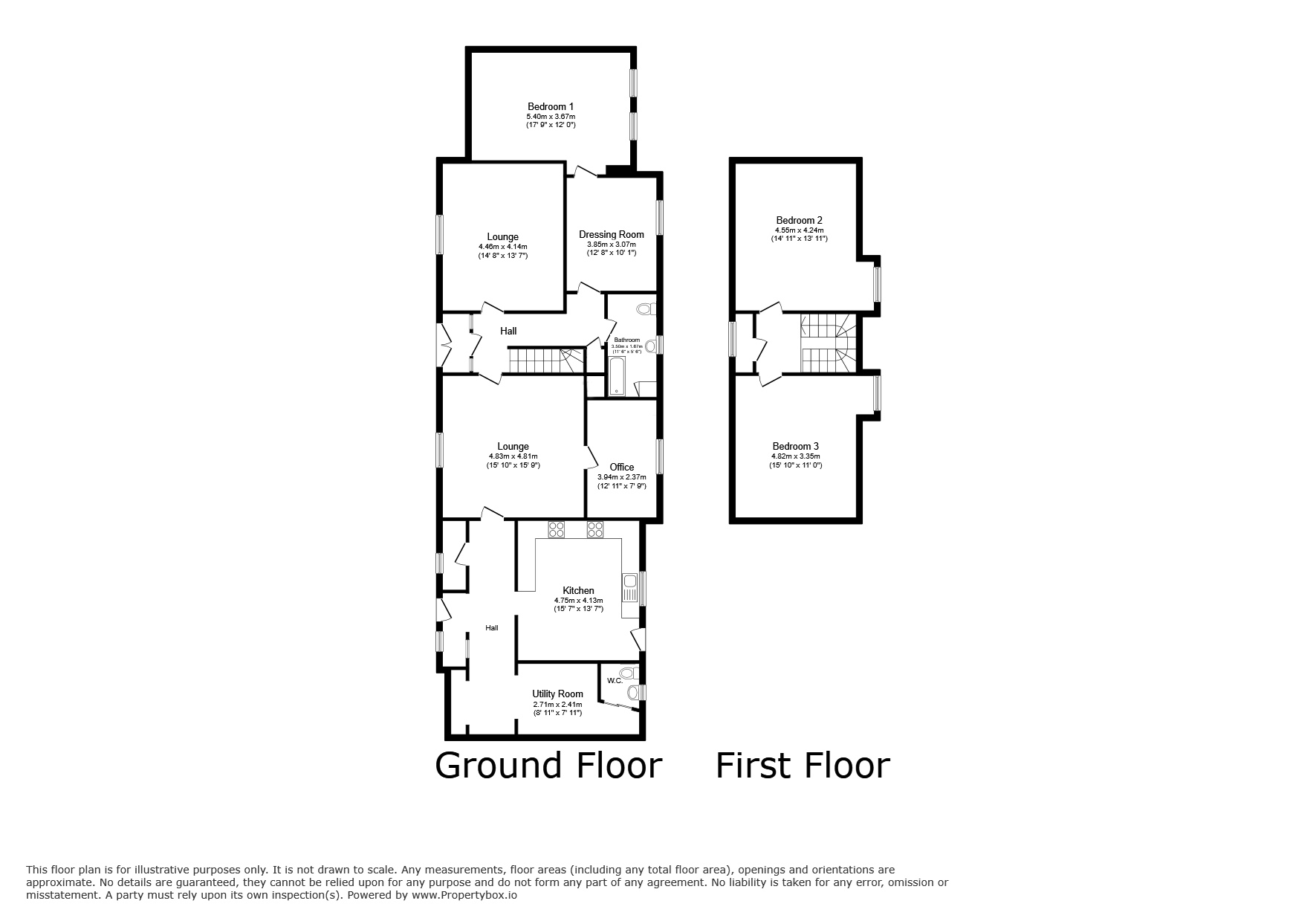
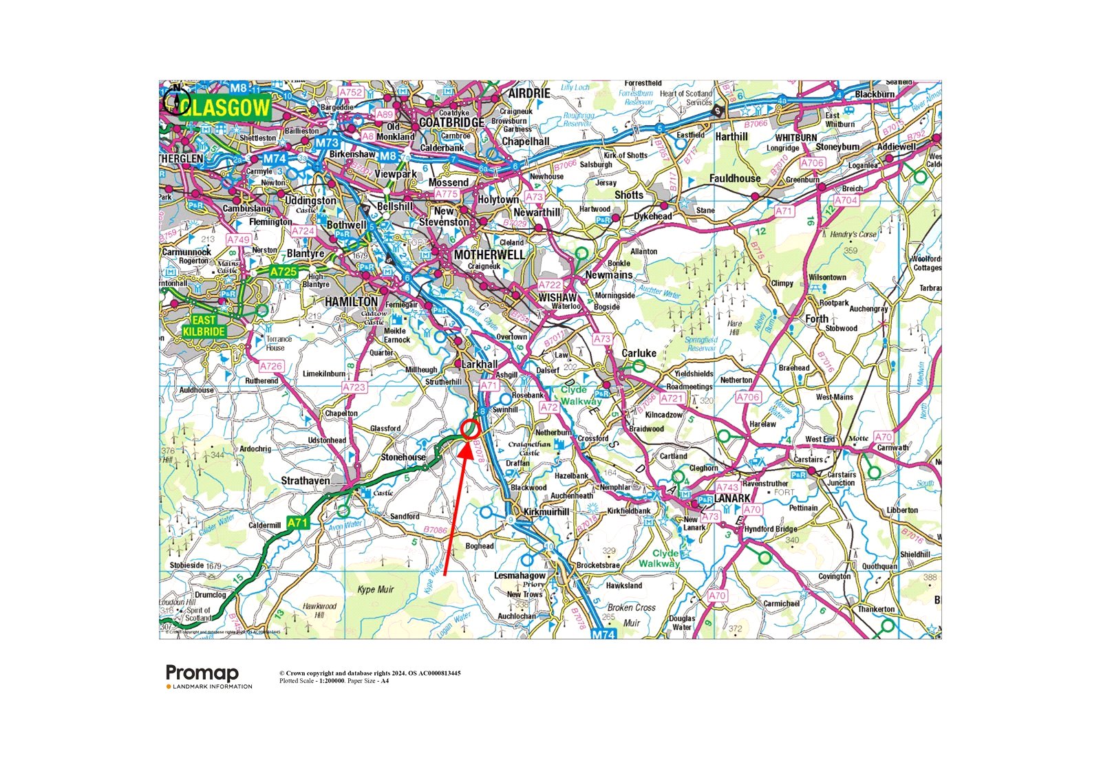
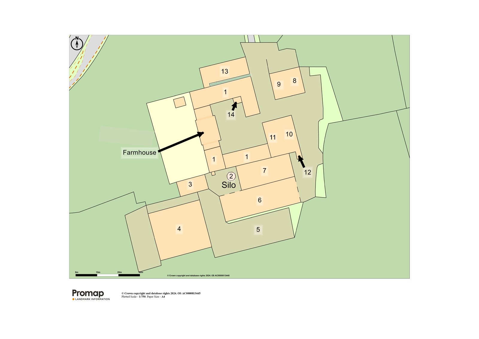
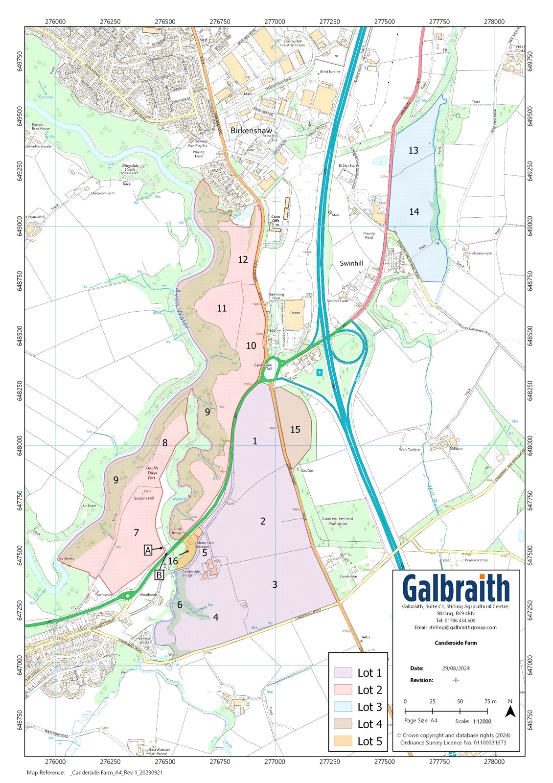
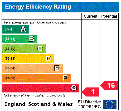
METHOD OF SALECanderside Farm is offered for sale as a whole or in 5 Lots. Please note Lots 2-5 will not be sold prior to the sale of Lot 1.LOT 1: FARMHOUSE, FARM BUILDINGS AND LAND EXTENDING TO APPROXIMATELY 48.08 HA (118.81 ACRES)Canderside FarmhouseThe farmhouse is situated within a traditional courtyard setting and centrally located within the principal block of arable and pasture land. The farmhouse sits in a private position within theholding and benefits from excellent access via the private farm drive which leads to the A71. The house enjoys a westerly aspect with views over the surrounding countryside. The property is constructed from traditional stone under a pitched slate roof and provides spacious accommodation over two levels. Internally, the farmhouse is in need of modernisation but presents a fantasticopportunity to refurbish the accommodation and extend by way of the adjacent buildings to form a substantial family home. The accommodation and room dimensions are detailed in the floor plan contained within the particulars.Garden GroundThe farmhouse is accompanied by a large and private area of garden ground which lies to the rear of the property and is mostly laid to lawn with a small paved patio area, a large vegetable patch, with several apple and plum trees and a greenhouse. The garden is enclosed by several mature trees providing shelter and privacy.Farm BuildingsThe range of modern and traditional farm buildings are situated in a group and lie immediately adjacent to the farmhouse with access via the adjoining public road. The buildings comprise the following:1. Traditional U-shaped SteadingLocated adjacent to the farmhouse, in a courtyard formation, the buildings comprise:Workshop (9.35m x 5.25m) of traditional construction under a slate roof with a concrete floor.Mill Shed (6.2m x 2.09m) of traditional construction under a box profile roof with a concrete floor.Garage (6.18m x 4.48m) of traditional construction under a box profile roof with a concrete floor.Former Dairy of stone construction under a box profile roof with a concrete floor.Outdoor WC with septic tank in garden.Traditional Byre (18.9m x 6.47m + 9.98m x 5.6m) of stone construction under a box profile roof with a concrete floor.Traditional Store (9.91m x 6.98m) of traditional stone construction under a box profile roof.2. 100 tonne Dry Grain Tower (last used in 2022).3. Brick Store (14.7m x 6.24m) of timber and brick construction under a corrugated roof with a concrete floor.4. Slatted Cattle Shed (24.15m x 21.45m) of steel portal frame construction under a corrugated roof with concrete and brick walls and a suspended slatted floor with 2 central feed passages for roughly 160 young stock.5. Silage Clamp - of shuttered concrete wall construction with a concrete floor.6. Dutch Barn with Lean-to (36.5m x 11.9m) of steel portal frame construction under a tin roof with brick walls and a concrete floor.7. General Purpose Shed (26.0m x 10.2m) of steel portal frame construction under a box profile roof with stone walls and a stone floor.8. Brick Store 2 (12.5m x 7.08m) of steel portal frame and brick construction under a corrugated roof with a concrete floor.9. Calf Shed (20.0m x 6.6m) of timber and brick construction under a corrugated roof with a concrete floor.10. Dutch Barn 2 (17.54m x 7.5m) of steel portal frame construction under a tin roof and tin side cladding with brick walls and a concrete floor.11. Hay Shed (17.2m x 6.43m) of timber frame construction under a slate roof with stone and brick walls and a concrete floor.12. Lean-to (3.78m x 3.76m) of tin roof and side cladding with an earth floor.13. Former Byre (21.2m x 7.47m) of brick and timber construction under a slate roof with a concrete floor.14. Coal Cellar (3.37m x 3.28m) of brick construction under a box profile roof with a concrete floor.Yard AreaThe farm buildings benefit from a large area of yard which is down to concrete and hard standing and provides additional space for fodder and machinery storage.Former Colliery OutbuildingsLocated to the south of the principal farm steading close to the southern perimeter of the subjects, there are the remains of some brick- built outbuildings, which originally formed part of the Canderrigg Colliery. The buildings are mostly intact to wall head level, with a further concrete yard area which is currently used as an area to store manure and also provide an area to feed any outwintered cattle.Farmland in Lot 1 extending to about 48.08 Ha (118.81 Acres)The land in Lot 1 lies within a contiguous block and extends to about 48.08 Ha (118.81 Acres) in total and surrounds the farmhouse and farm buildings. The farmland within Lot 1 is bound to the north by the A71, to the east by the B7078, and to the south by Candermill Road, providing an excellent level of direct road access to each enclosure. The land has been principally classified by the James Hutton Institute as Grade 3.2 and comprises a mix of productive arable and grazing ground, with some small areas of amenity woodland located to the north west of the farm steading and along the eastern bank of the Cander Water. The land varies in aspect rising from 115m adjacent to the Cander Water on the south western boundary to 174m above sea level at its highest point adjacent to the B7078 public road on the south eastern boundary. The fields have benefited from a healthy application of farmyard manure over the years due to their proximity to the farm steading with the majority of the enclosures being accessed directly from the farm steading or via field gates which lead directly off the various public roads.CLAWBACKThe missives of sale of Lots 1 -4 will be subject to the Purchaser(s) granting a standard security in favour of the Sellers to clawback 30% of the uplift in value, in the event of planning permission being granted for development for any purpose other than agricultural, over any part of the holding being obtained subsequent from the date of entry for a period of 30 years.POST CODEML9 3PJWHAT3WORDSTo find this property location to within 3 metres, download and use What3Words and enter the following 3 words or click on the links below:Lot 1: https://what3words.com/themes.romantics.strayingLot 2: https://what3words.com/hydrant.excavate.changedLot 3: https://what3words.com/challenge.stutter.blotchyLot 4: https://what3words.com/whites.airtime.unscathedLot 5: https://what3words.com/hack.jobs.clatteredVIEWINGStrictly by appointment with the Selling Agents.HEALTH & SAFETYThe property is an agricultural holding and appropriate caution should be exercised at all times during inspection particularly in reference to the farm buildings, farm land and water courses.MINERALSThe mineral rights are included insofar as they are owned by the Seller.TIMBERAll fallen and standing timber is included in the sale insofar as it is owned by the Seller.SPORTING RIGHTSInsofar as these rights form part of the property title they are included within the sale.FIXTURES AND FITTINGSNo other items are included unless mentioned in the sales particulars.LOCAL DEVELOPMENT PLANPart of the land within Lot 2 being fields 7, 8 and part of 10 has been designated as a Special Landscape Area within the South Lanarkshire Council Local Development Plan which was adopted 2021.HISTORIC DESIGNATIONS - CANDERSIDE BRIDGEThe ground forming Lot 1 encompasses a Thomas Telfer bridge known as the “Canderside Bridge” which spans the Cander Glen and Cander Water to the west of the farm steading. The bridge historically formed part of the Edinburgh-Ayr road over the Cander Water before the route was bypassed in 1965. Built between 1820-23 the Bridge has been afforded an A-Listing status by Historic Environment Scotland under the Planning (Listing Buildings and Conservation Areas) (Scotland) Act 1997. It is a smaller, unaltered version of Telford’s Cartland Bridge at Lanark, and the only surviving Telford bridge of its type.ENVIRONMENTAL DESIGNATIONSThe majority of the woodland and some of the land surrounding the Avon and Cander Water within Lot 2 to the north and east of the holding is all designated as the Avondale Site of Special Scientific Interest (SSSI) and also a Special Area of Conservation (SAC).THIRD PARTY RIGHTS AND SERVITUDESThe property is burdened by a core path which forms a core path loop from the village of Stonehouse to Cander Bridge and roughly follows the field margin of enclosure No 8 within Lot 2 to the north west of the property on the north side of the A71.The property is burdened by the Daer Water Main which passes through the western boundary of fields 7 and 4 of the sale plan.Lot 3 is burdened by service rights in favour of SP Distribution PLC in respect of the neighbouring sub-stations which are located on the southern boundary of the lot.The subjects are sold together with, and subject to, all existing rights of way, servitudes, wayleaves and others whether contained in the Title Deeds or otherwise, and purchasers will be deemed as satisfied themselves in respect thereof.There is a high pressure gas main crossing part of Lot 1, to the north of farm steading, and the the southern boundary of lot 4.Avon Angling Club have the rights to fish on the Avon Water forming the western boundary of Lot 2 and issue permits, The angling club also take pedestrian access to the Avon Water via land forming Lot 2.DEPOSITA deposit of 10% of the purchase price shall be paid within seven days of completion of Missives. Deposit will be non-refundable in the event of the purchaser failing to complete for reasons not attributable to the Seller or their Agents.POSSESSION AND ENTRYVacant possession and entry will be given on completion or such mutual time to be agreed by the Seller and the Purchaser(s).ANTI MONEY LAUNDERING (AML) REGULATIONSPlease note that under the 2017 AML regulations we are legally required to carry out money laundering checks against purchasers. Upon verbal acceptance of an offer, we require to identify the purchaser for Anti-Money Laundering purposes. Our service provider ‘First AML’ will contact the purchaser to gather the required identification documents. An information sheet is available from the selling agent on request. We are not able to enter a business relationship with a purchaser until they have been identified. Failure to provide required identification may result in an offer not being considered.AMC PLC FINANCEGalbraith are approved Agents for the Agricultural Mortgage Corporation (AMC) and we can assist you in securing finance loans for a variety of farming purposes including the purchase of land and property, restructuring debt, and to provide working capital for diversification, improving or erecting farm buildings. For further details and to discuss any proposals in confidence please contact Alistair Christie in our Galbraith Stirling office on 01786 435047 Email: alistair.christie@galbraithgroup.com